
GPR Surveys & Concrete Scanning across Sussex & Surrey
Ground penetrating radar for buried services, voids and structures, and concrete scanning of slabs and walls – across West Sussex and Surrey, from our head office in Horsham.
Call Us For A Free Quote 0345 548 5451- Proceq GS8000 utility GPR
- Proceq GP8000 concrete scanning
- Results drawn in CAD & marked on site
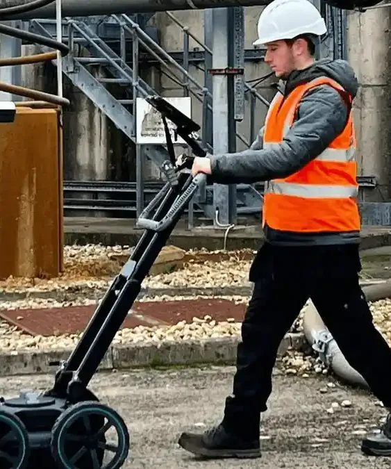
GPR surveys in Sussex & Surrey
Many of our clients call a utility survey a GPR survey, and for good reason: ground penetrating radar finds services that standard cable locators cannot. GPR sends radar pulses into the ground and records the reflections from pipes, ducts, chambers, voids and buried structures, whether they are metal, plastic, clay or concrete.
For buried services we use GPR together with electromagnetic location as part of a PAS128 utility survey in West Sussex or Surrey. For structures, we scan concrete to locate reinforcement and embedded services before cutting, coring or drilling. Our head office is in Horsham, so sites across both counties are within easy reach.
Contact usGPR for buried services and ground features
- Plastic water and gas pipes and empty ducts
- Clay and concrete drains and culverts
- Chambers, tanks and buried structures
- Voids and areas of disturbed ground
- Old foundations and obstructions before piling
- Detailed GPR grids for congested sites, processed and interpreted in the office
We use the Proceq GS8000 subsurface utility GPR alongside Radiodetection RD8200 and RD8100 locators, with results positioned on OS National Grid and drawn in CAD.
Concrete scanning (ferroscanning)
- Rebar position, spacing and cover
- Post-tension tendons in slabs and transfer structures
- Embedded conduits and pipes
- Slab thickness and voids
- Safe zones marked out for coring, drilling, anchors and saw-cutting
We scan with the Proceq GP8000 concrete GPR, marking results directly on the surface and providing a short report with images where required.
How Sussex and Surrey ground affects GPR
GPR results depend on the ground. Across our two counties the geology changes quickly, so we plan every survey around it rather than assuming one method works everywhere.
- Weald Clay around Horsham, Crawley and Burgess Hill absorbs radar, especially when wet, so EML, signal transmitters and chamber inspections do more of the work.
- Sands around Woking, Camberley and parts of Reigate generally give good GPR depth.
- Chalk on the South Downs and North Downs usually suits GPR, and can show voids and solution features.
- Coastal ground at Worthing, Shoreham and Chichester can be wet and salty, which reduces GPR depth near the sea.
GPR surveys – areas we cover
Our GPR and PAS128 utility survey pages for each area of Sussex and Surrey.
Utility & GPR survey Horsham
PAS128 utility surveys and GPR surveys across Horsham town and district, from our head office in Horsham itself.
View areaUtility & GPR survey Crawley & Gatwick
PAS128 utility surveys and GPR surveys across Crawley, Manor Royal and the Gatwick area, a short drive from our Horsham head office.
View areaUtility & GPR survey Chichester
PAS128 utility surveys and GPR surveys across Chichester city, the coastal plain and the Manhood Peninsula, from our Horsham head office.
View areaUtility & GPR survey Worthing
PAS128 utility surveys and GPR surveys across Worthing, Shoreham, Lancing and the Adur and Arun coast, straight down the A24 from Horsham.
View areaUtility & GPR survey Haywards Heath & Burgess Hill
PAS128 utility surveys and GPR surveys across Haywards Heath, Burgess Hill and Mid Sussex, a short drive from our Horsham head office.
View areaUtility & GPR survey Guildford
PAS128 utility surveys and GPR surveys across Guildford, Godalming and Cranleigh, straight up the A281 from our Horsham head office.
View areaUtility & GPR survey Woking
PAS128 utility surveys and GPR surveys across Woking, Byfleet, West Byfleet and Knaphill, from our Horsham head office.
View areaUtility & GPR survey Reigate & Redhill
PAS128 utility surveys and GPR surveys across Reigate, Redhill, Horley and Merstham, a short drive north of our Horsham head office.
View areaUtility & GPR survey Epsom & Leatherhead
PAS128 utility surveys and GPR surveys across Epsom, Ewell, Leatherhead and Ashtead, straight up the A24 from our Horsham head office.
View areaUtility & GPR survey Camberley & Farnham
PAS128 utility surveys and GPR surveys across Camberley, Frimley, Farnham and the Blackwater Valley, from our Horsham head office.
View areaGPR Surveys in Sussex & Surrey | Frequently Asked Questions
Q1: What can GPR find that a cable locator cannot?
A: A cable locator (EML) only finds metallic services or those carrying a signal. GPR also picks up plastic water and gas pipes, empty ducts, clay and concrete drains, chambers, voids, old foundations and buried structures.
Q2: Is a GPR survey the same as a PAS128 survey?
A: GPR is one of the detection techniques used in a PAS128 survey. For buried services we use GPR together with EML, and report the results to PAS128 quality levels.
Q3: What is concrete scanning or ferroscanning?
A: Concrete scanning uses a high-frequency GPR to locate reinforcement, post-tension tendons, conduits and voids inside slabs, walls and columns, so cores, fixings and cuts can avoid them.
Q4: Does GPR work on Sussex and Surrey ground?
A: It depends on the site. Sandy ground around Woking, Camberley and parts of Reigate, and the chalk of the Downs, generally suit GPR well. Wet Weald Clay around Horsham, Crawley and Burgess Hill, and salty ground on the coast, reduce depth penetration. That is why we use GPR with EML and explain any limitations in the survey report.
Q5: How much does a GPR survey cost?
A: GPR surveys are priced on the area, the grid density, access and the reporting needed. Send us a plan or photos of the area and we will come back with a fixed quote, usually the same or next working day.
Need a service & ready to book? Call us 0345 548 5451
Email usWhy choose Ambler Group for GPR surveys and concrete scanning in Sussex & Surrey?
Head office in Horsham
Our head office is in Horsham, West Sussex, so your site in Sussex & Surrey is covered by our southern survey teams – a local firm that knows the area.
Utility surveyors first
Detecting buried services is our core work, using EML and GPR together and reporting to PAS128 quality levels so you know how far to rely on each line.
Everything in one visit
PAS128 utility, GPR, topographical and CCTV drainage surveys from one team, with one set of RAMS and one coordinated set of drawings.
If you’re looking for reliable, professional GPR surveys and concrete scanning in Sussex & Surrey, contact us today!
Clients Reviews
“Ambler Group have been our number one go to for all of our topographical, UGS & GPR Surveys.”
Ryan, Director – Topographical, Utility and GPR
Helpful survey guides
PAS128 Quality Levels Explained: QL-D to QL-A
What QL-D, QL-C, QL-B1 to B4 and QL-A mean on a utility drawing, and which one your project needs.
Read the guide GuideWhat Does a PAS128 Utility Survey Cost?
The factors that set the price of a PAS128 or GPR utility survey, and what to send for a fast, fixed quote.
Read the guide GuideUtility Records in England: STATs Searches, LSBUD and NUAR
Where utility records come from in England, what NUAR does and does not give you, and why records alone are not enough.
Read the guideContact Us
Book a survey in Sussex & Surrey
For a fast, fixed quote, send us:
- The site address or postcode
- A site plan or marked-up aerial image showing the survey area
- What the survey is for – design, planning, excavation, piling or records
- Access notes – working hours, permits, inductions
We usually come back with a fixed quote the same or next working day.
Head office:
Ambler Group Limited
Springfield House, Springfield Road,
Horsham RH12 2RGCompany registration number: 12568344
Areas we cover:
Horsham, Crawley and Gatwick, Haywards Heath and Burgess Hill, Worthing, Chichester, Guildford, Woking, Reigate and Redhill, Epsom and Leatherhead, Camberley and Farnham – and the rest of Sussex, Surrey and the South East.